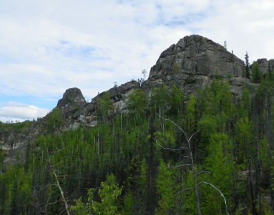
Allow 3-4 hours to complete the loop hike. From the Angel Rocks trailhead, the trail parallels the North Fork of Chena River through mixed spruce and birch, before reaching a junction. Head right on the Angel Rocks Trail (the trail on the left is the Angel Rocks loop trail and a possible return route). The angel Rocks trail crosses a boggy area on a boardwalk before beginning the ascent through the forest. The trail turns sharply uphill for a short distance before coming to Overlook Rock (the first tor). It starts a moderately steep ascent, passing by many tors before emerging onto the ridge-top
Trail Access: Mi. 48.9 Chena Hot Springs Road.
Allowable Uses: Hiking, Horseback Riding
Distance: 3.7 mile loop
Elevation Gain: 900 feet
Difficulty: Moderate