The first 111 miles of the Wild River segment are within the White Mountain National Recreation Area (south of the Refuge) and is managed by the Bureau of Land Management. The final 16 miles of the Wild River segment are in the Refuge; however, Beaver Creek continues to flow north then westward for another 164 miles before draining into the Yukon River. There are no roads or services until you reach the Yukon River bridge on the Dalton Highway which is another 65 miles from the confluence of Beaver Creek and the Yukon River.
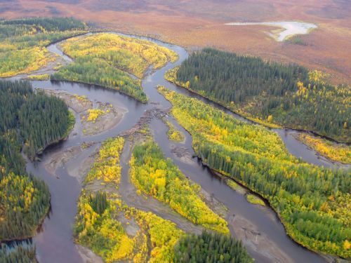
Boaters putting in at the headwaters of Beaver Creek National Wild River, on BLM lands are treated to the rugged and spectacular country of the White Mountains before the creek flows north, and enters the Yukon Flats National Wildlife Refuge. The last 16 miles of the 127 mile Beaver Creek designated Wild River are within the Yukon Flats National Wildlife Refuge.
The Beaver Creek floodplain is bordered by rocky cliffs between river mile 112 to 127. Here it is common to see Dall sheep and peregrine falcons along the cliffs. The surrounding forest is composed of white and black spruce), Alaska birch, and balsam poplar. Willow and other herbaceous plants are common on river gravel bars. Ice wedges are evident in the exposed river banks. Moose, bear, and wolf tracks are common on sandy bars, which are also nesting areas for shorebirds. Beaver Creek also has populations of Arctic grayling as well as other fish, including northern pike and salmon.
Beaver Creek is a popular destination for river floaters. Depending on where you put-in and take out, the float can take anywhere from one week to several weeks to complete. For a shorter trip, arrangements can be made with an air taxi. A common option taken is a drop-off near Victoria Creek and then float for up to two weeks to the take out at the Dalton Highway Bridge. If the trip is begun at the headwaters, the 360-mile float trip has been called the longest road-to-road float in North America.